Buildings & Sites

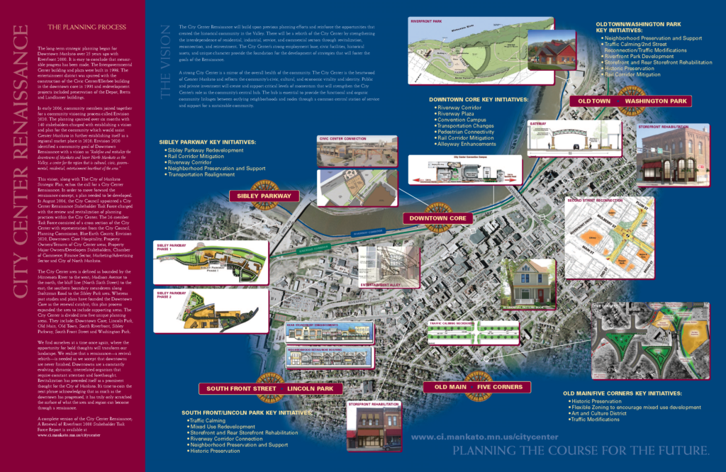
The Greater Mankato regional marketplace is full of options to suit your land and building needs.

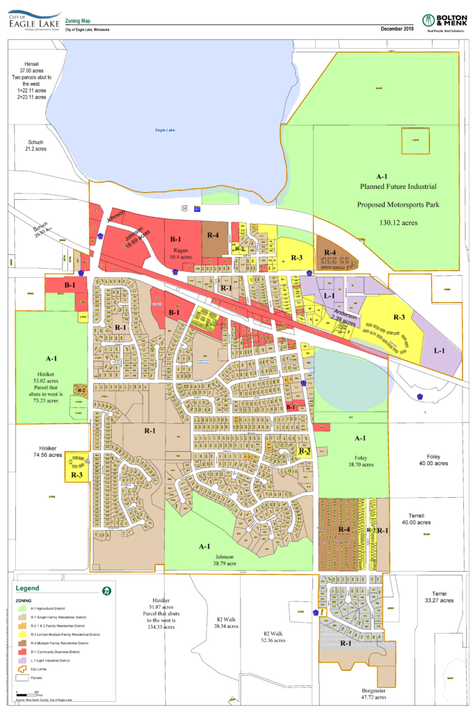
Search for available properties using the search tool on this page or contact us to get more information. Because we represent five cities and two counties, we are able to provide you with more options and resources across our entire region. When you work with us, we can assist and connect you to all our Regional Economic Development Alliance (REDA) partners: Eagle Lake, Lake Crystal, Mankato, North Mankato, Saint Peter, Madison Lake, Blue Earth County, and Nicollet County.

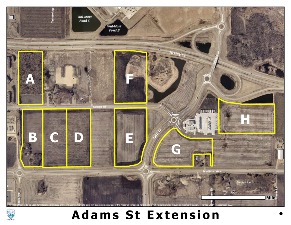
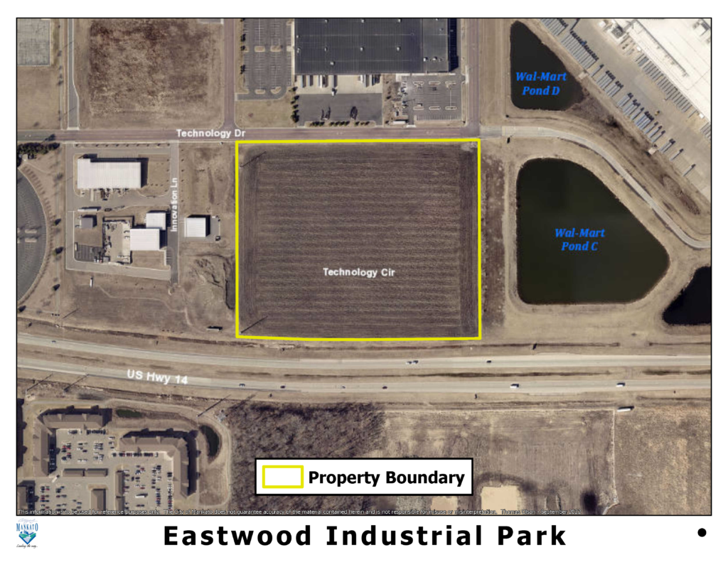
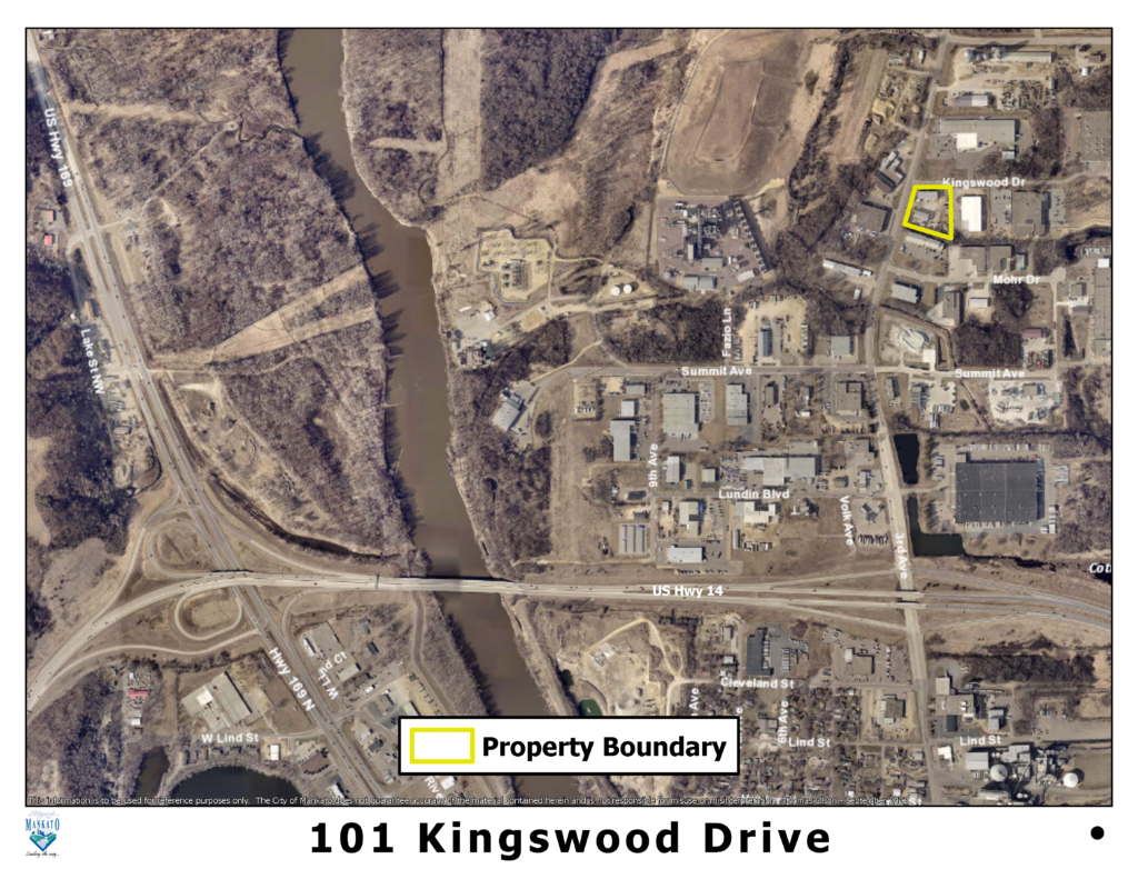
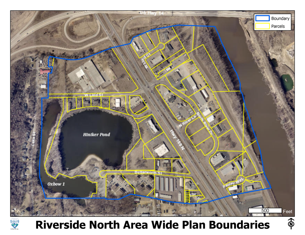
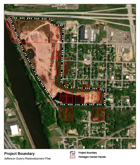
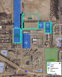
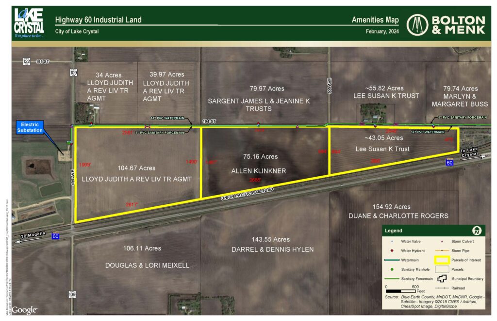
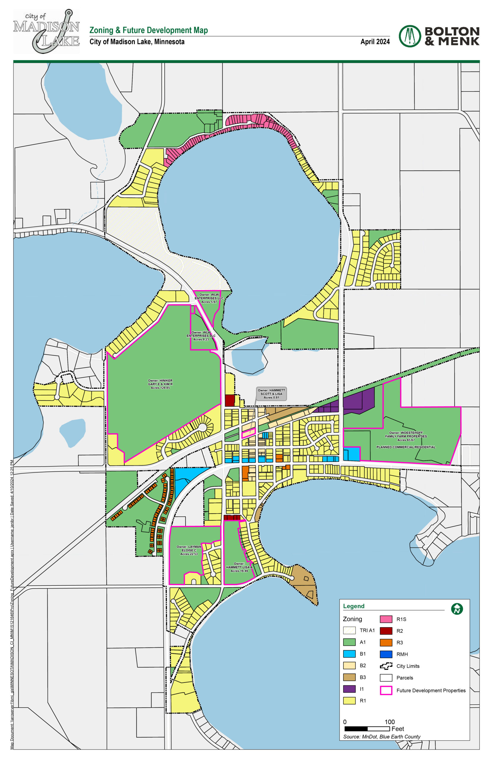
In addition to these sites, the Cities in the partnership have highlighted their land or buildings that have been targeted for industrial or commercial development. Find these targeted sites in our Industrial Parks and Land section below.

Learn more about Industrial Parks within the region

ready for development

Industrial Parks & Land

If you’re looking for land or buildings that have been targeted for development, take a look at the priority areas for each community below. Communities may include city-owned land, privately owned land targeted for industrial or commercial development, or vacant buildings that are targeted for a new user.

Mankato

A. Parcel ID: R430910400010

  • Owner: Theodore Halter, 1800 60th St E, Inver Grove Heights, MN 55077
  • Lot Area: 5 acres (544,500 square feet)
  • Visibility from U.S. Highway 14. Access to U.S. Highway 14 (intersects with U.S. Highway 169), MN Highway 22, CSAH 12.
  • Contact: Mary Brau 651-455-7706
  • Assessments: $0 assessment for qualifying industrial development per development agreement.


B. Parcel ID: R430910400012

  • Owner: Theodore Halter, 1800 60th St E, Inver Grove Heights, MN 55077
  • Lot Area: 11.37 acres (461,200 square feet)
  • Access to U.S. Highway 14 (intersects with U.S. Highway 169), MN Highway 22, CSAH 12.
  • Contact: Mary Brau 651-455-7706
  • Assessments: $0 assessment for qualifying industrial development per development agreement.


C. Parcel ID: R430910400015

  • Owner: Duane and Cathy Halter, 1800 60th Street E, Inver Grove Heights, MN 55077
  • Lot Area: 13.64 acres (594,158 square feet)
  • Access to U.S. Highway 14 (intersects with U.S. Highway 169), MN Highway 22, CSAH 12.
  • Contact: Mary Brau 651-455-7706
  • Assessments: $0 assessment for qualifying industrial development per development agreement.


D. Parcel ID: R430910400018

  • Owner: Brau Living Trust, 1800 60th Street E, Inver Grove Heights, MN 55077
  • Lot Area: 13.59 acres (591,980 square feet)
  • Access to U.S. Highway 14 (intersects with U.S. Highway 169), MN Highway 22, CSAH 12.
  • Contact: Mary Brau 651-455-7706
  • Easements: Potential for a gas line easement on the eastside of the property.
  • Assessments: $0 assessment for qualifying industrial development per development agreement.


E. Parcel ID: R430910400009

  • Owner: Marx Gregory Earl ETAL, 22677 6045th Avenue, Madison Lake, MN 56063
  • Lot Area: 16.93 acres (737,471 square feet)
  • Access to U.S. Highway 14 (intersects with U.S. Highway 169), MN Highway 22, CSAH 12.
  • Contact: Dennis Terrel 507-340-4562
  • Assessments: $0 assessment for qualifying industrial development per development agreement.


F. Parcel ID: R430910400007

  • Owner: Marx Gregory Earl ETAL, 22677 6045th Avenue, Madison Lake, MN 56063
  • Lot Area: 16.21 acres (582,000 square feet)
  • Access to U.S. Highway 14 (intersects with U.S. Highway 169), MN Highway 22, CSAH 12.
  • Contact: David Schooff, [email protected] or 507-625-4715
  • Assessments: $0 assessment for qualifying industrial development per development agreement.


G. Parcel ID: R430911300021

  • Owner: BT Development LLC, 2205 7th Avenue, Mankato, MN 56001
  • Lot Area: 16.61 acres (723,532 square feet)
  • Access to U.S. Highway 14 (intersects with U.S. Highway 169), MN Highway 22, CSAH 12.
  • Contact: David Schooff, [email protected] or 507-625-4715


H. Parcel ID: R430911300013

  • Owner: BT Development LLC, 2205 7th Avenue, Mankato, MN 56001
  • Lot Area: 16.5 acres (718,740 square feet)
  • Access to U.S. Highway 14 (intersects with U.S. Highway 169), MN Highway 22, CSAH 12.
  • Contact: David Schooff, [email protected] or 507-625-4715


Click here to download the full document.

Parcel ID: R010910200011

  • Owner: MAVCO Investments LLC, 151 St. Andrews Court, Suite 610, Mankato, MN 56001
  • Building Size: 7,200 square feet (1,812-7,200 square feet available between 4 units)
  • Contractor park, warehouse condos include office space, restroom and heated warehouse including dedicated private outdoor storage. Units include an OH door (16’ x 12’), trench drain and an option to add a mezzanine.
  • Access to U.S. Highway 14 (intersects with U.S. Highway 169)
  • Contact: David Schooff, [email protected] or 507-625-4715

Click here for a larger image.

Parcel ID: R010431454004

  • Owner: Richard Dittrich, 101 Kingswood Drive, Mankato, MN 56001
  • Lot Area: 2.75 acres (119,625 square feet)
  • Buildings: 2 industrial buildings. The 1st building is 10,650sf with 9,600 square feet of open space and the 2nd building is 7,200 square feet. Buildings include (2) 10-Ton Crane with 5-Ton Lifts and 3 OHDs (16’x14′, 19’x16′ and 22’x18′). The property has 8″ concrete floor in each building with in-floor heat. Equipment is negotiable.
  • Located off of 3rd Avenue with access to U.S. Highway 14
  • Contact: David Schooff, [email protected] or 507-625-4715


Click here for a larger image.

The Riverside North area serves as a gateway into the city for anyone traveling south on Highway 169 towards downtown Mankato. While there are some newer highway commercial uses along the corridor, several of the adjacent properties are vacant or underutilized commercial and industrial properties. The Riverside North Area Wide Plan explores the market potential for redevelopment in the area, and specific redevelopment concepts for a few key sites. The full plan can be downloaded via this link (PDF).

Map highlighting the boundaries of Mankato's Riverside North Area Wide Plan. Displays an image of US Hwy 169 just south of the US HWy 14 interchange with a line surrounding businesses in the area.

Click here for a larger image.


The City Center Renaissance Plan was completed in 2007. As the update to 25 years of prior planning, the City Center Renaissance Plan continues to be the guiding document for development in the City Center. The plan can be found at City Center Renaissance Plan | Mankato, MN (mankatomn.gov).

Click here for to download City Center Renaissance Map Summary.

North Mankato

This site includes a Deloitte certified shovel ready data center site, click here to view details.

Price Per Acre (for city-owned land): $65,000 – $75,000 per acre

Location: Near the intersection of Highway 14 and CSAH 41

Land Area: 3 acres and up

Zoning: M-2, Heavy Industrial/Commercial

Incentives: TIF, Low Interest Loan

Utility Providers: 

  • Water: City of North Mankato
  • Natural Gas: CenterPoint Energy
  • Electricity: Benco
  • Telecom: Consolidated Communications, Spectrum, & MetroNet

Click here for PDF Map download

Saint Peter

Price Per Acre: $45,738 per acre

Location: Less than 1 mile from Highway 169

Land Area: 1 – 22 acres

Zoning: Industrial

Incentives: TIF

Utility Providers: 

Water: City of Saint Peter
Natural Gas: CenterPoint Energy
Electricity: City of Saint Peter
Telecom: CenturyLink or Consolidated Communications


Click here to enlarge photo

Eagle Lake


Logo for the City of Eagle Lake containing the text "City of Eagle Lake - Where Opportunity Soars"

Eagle Lake has targeted land abutting Highway 14 for commercial development. There are roughly 29 contiguous acres abutting highway 14 currently zoned for commercial development with an additional 30 acres to the west. Those intersted in other developments may find this Zoning Map, which highlights ownership and acreage of developable land, helpful.  Developers interested in getting in touch with landowners are encouraged to contact Jennifer Bromeland, Eagle Lake City Administrator, at [email protected] 

Incentives: May consider tax abatement or TIF

Utility Providers:

Water: City of Eagle Lake

Natural Gas: CenterPoint Energy & Greater MN Gas (Southeastern City Limits)

Electricity: Xcel Energy & BENCO (Southeastern City Limits)

Telecom: Consolidated Communications & MetroNet

An image of a zoning map for the City of Eagle Lake, which outlines the ownership and acreage of undeveloped land. A pdf of the map will be downloadable when clicked.

Click here for to view Full Size PDF of Map

Lake Crystal

CityofLakeCrystal LOGO

Location: Highway 60, Lake Crystal, MN 56055

Land Area: 900+ Acres


Learn more about the communities within the Greater Mankato Region

en_USEnglish